

Other then being a tech enthusiast, I am also a running fanatics. With 27 marathons (and counting) under my belt, I am always looking for new challenges to keep my running experience fresh and fun. I recently heard about the new Coast to Coast trail that NParks has been promoting, I thought it would be an accomplishment to complete it by running the entire route. Finally the right moment has come to execute my plan, as I was given a day off on 1st July (a special day to me).
This post aims to document my experience and hopefully will be useful to those who wanted to walk/run the same trail.
About the trail
According to Nparks:
” The Coast-to-Coast Trail is a 36 km trail that spans across Singapore. Stretching from Jurong Lake Gardens in the west to Coney Island Park in the northeast, a total of 10 checkpoints will take you through 18 parks and nature areas and 11 park connectors.You can choose to explore the Trail on your own using the C2C online Trail Guide or using the C2C Mobile App.”
My advice is to skip the poor mobile app (which only has a 1+ star rating) and use the “Online Trail Guide” (pdf downloadable) as your planning guide. You should know the route well before setting off especially if you are running as you would not want to look at the phone for directions all the time.
There are altogether 9 checkpoints (I am excluding CP10 as it is out of the way) and I will list them down in the post below. I had mostly followed the official route but had taken a few detours that I felt were more logical.
The distance given by NParks is 36KM but I had recorded a distance of about 40KM on my AmazFit Stratos GPS watch, probably due to GPS inaccuracy (as some parts of the run is under the MRT track) or the detours I had taken. But based on my own estimates, the total distance is still about 36++KM, so be prepared.
Preperation
After studying the route the previous night, I set an alarm for 5am on 1st of July 2019. Woke up on the dot, and had my usual bulletproof coffee as my breakfast. I took along a hydration pack, my phone, Ez-link card and some cash.
But disaster struck before I begin as I discovered my hydration pack was leaking. So I had to carry on without it as I thought I can still get water from the toilet tap/water cooler or buy drinks along the way. In hindsight, this was probably a blessing in disguise as I can run more freely without the burden of the hydration pack.
I only managed to leave home at 7am due to this small episode and arrived at Chinese Garden and start the run at 7:40am, which meant I had to deal with more of the intense afternoon heat later on.
CP1 Jurong Lake
At Chinese Garden MRT station, I did some light warm up and begin my run.

I took the path towards Chinese Garden and turned left when I see the main gate and the iconic tower

In case you are lost, just look for these sign posts along the way (about a few hundred meters apart). You should see this along the designated route with information like next landmark/checkpoint, toilet and distance. If you don’t see them, you are probably on the wrong track.

The route to CP2 (Bukit Batok Nature Park) would mostly be under the MRT tracks along Boon Lay Way, turned left to Jurong East Central, and just follow along the park connector Jurong Park Connectors to Toh Guan, go across the PIE, run along the Ulu Pandan park connectors towards Bukit Batok Ave 6, Bukit Batok Ave 3, turning into Hillview Park Connector before reaching the entrance of Bukit Batok Nature Park.

Found a statue of my “animal” along the way.

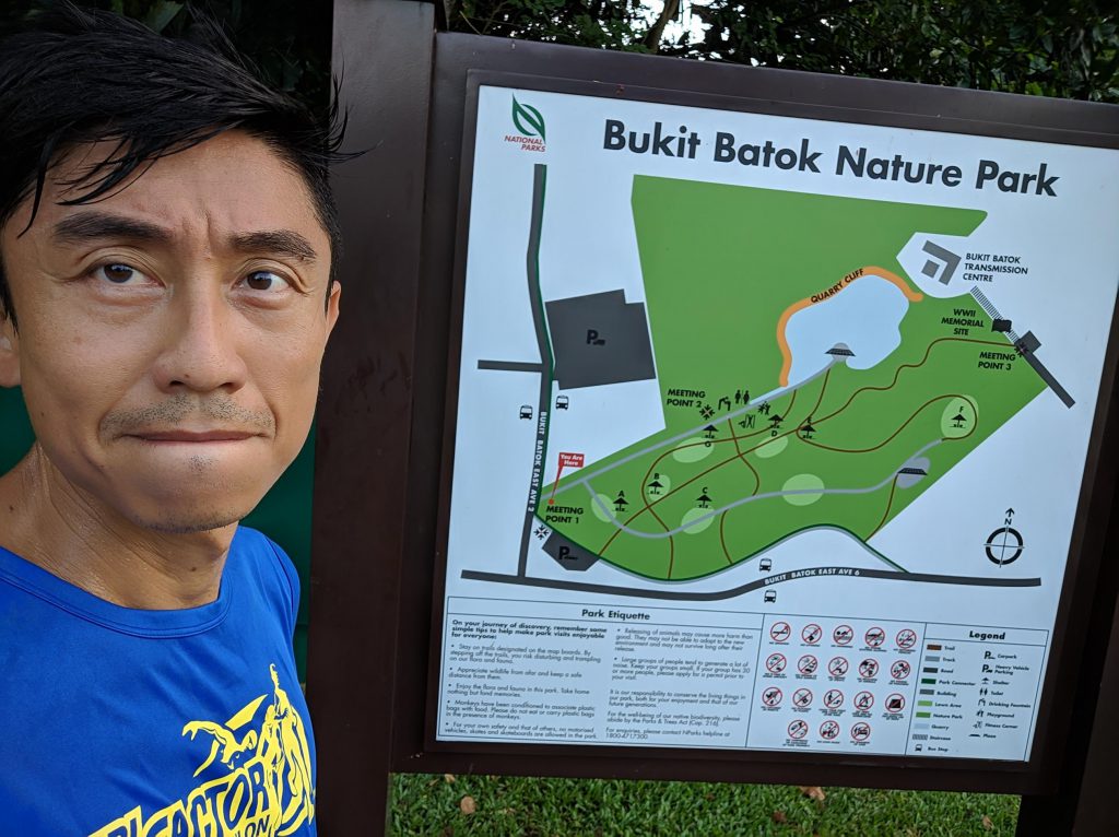
CP2 Bukit Batok Nature Park
After arriving at the park entrance, I ran down the route leading into the park (towards the pond) as I know there is a toilet with water cooler there. You can check the Park map on the sign shown below for more details
I ran back from the park toilet to the entrance again after a drink at the water cooler, and turned left towards the car park, entering the Bukit Batok Park Connector and ran along the old Jurong Road towards Upper Bukit Timah Road. I made a right at the junction when I saw the old Bukit Timah Fire station, after a few hundred meters, I reached CP3 (Hindhede Drive), which is the entrance to the road leading to the Bukit Timah Hill summit.

CP3 Hindhede Drive
Went topless mode as it was getting hot. A quick selfie and I proceeded up the railway bridge behind me in the shot below.

Here, I took my first detour. The original route requires me to head down Beauty World towards Bukit Timah road, passing Pei Hwa Presbyterian Primary School (My old school), but I felt it would be more fun to run along the old railway corridor. Thus I went up the short railway bridge that you see in the picture behind me. There were lots of constructions going on and I had to exit near Bukit Timah Plaza, made a left turn and another left turn at the bus stop towards Rifle Range road. Ran a few hundred meters along Rifle Range towards Bukit Timah road junction. Crossed the overhead bridge towards the King Albert MRT side of the road and continue on the long stretch of Bukit Timah Road.
Map with red line indicating the detour I had taken

The long stretch along Bukit Timah Road before hitting CP4 (Adam Road Food Center)

Passed by my secondary school, so a customary selfie before continuing.


Continue on towards Coronation Plaza, cross the overhead bridge there and head towards CP4.
CP4 Adam Road Food Center
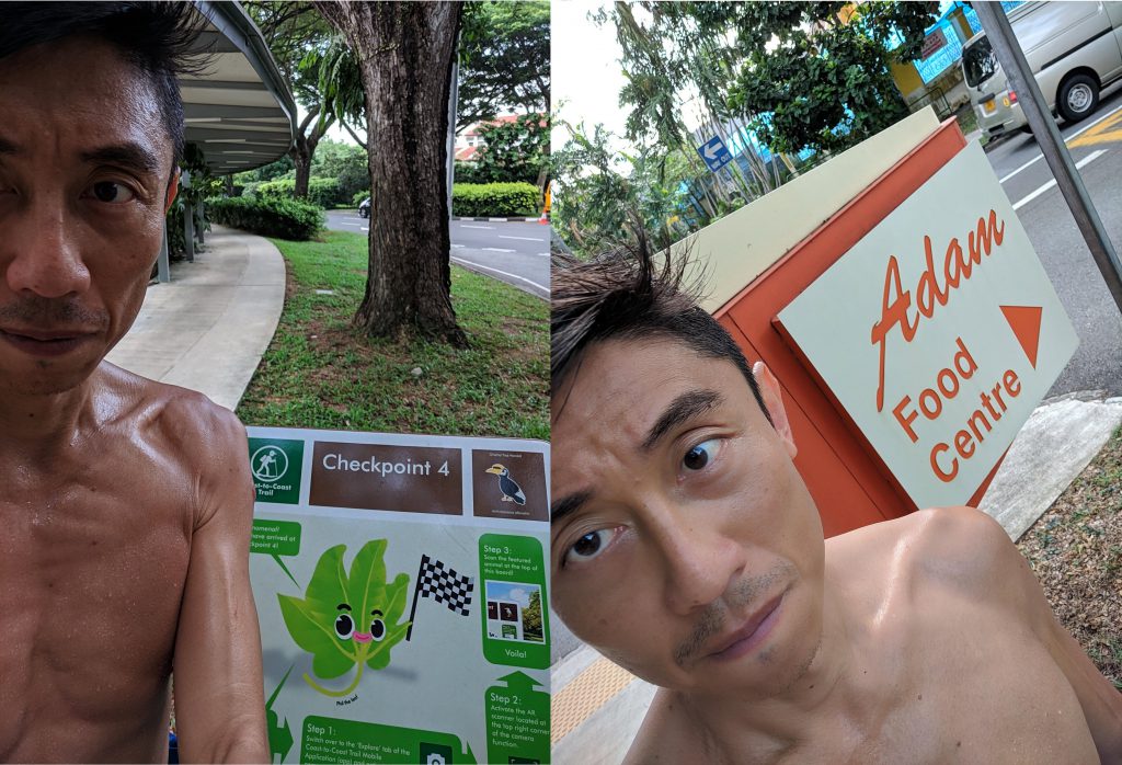
I went in to the hawker center to get a drink. I asked uncle what non-sugary drink do you have (remember that I had yet to have breakfast and I do not want to break my fast yet). Only Ayataka was available, I bought and drank it as there was no other alternatives.
I looked around and saw a long queue.

WARNING!! The next CP (Bishan Park) is super far, so be prepared.

I first had to run towards Japanese Association along Adam road towards Kheam Hock Park. You will see a small wooden walkway at the PIE exit towards Adam Road.

Next I made a left along Kheam Hock Road (you will still see some graves along the way) towards the old Lornie Road. Note that you need to keep to the right of Kheam Hock Road and cross an overhead bridge (across Lornie Highway). You should see the entrance to Island Country club.

After the new Lornie Highway was built (cutting across Bukit Brown), I always wondered where the old Lornie road disappeared to. Now I know, and it was pretty much deserted during morning peak hours.

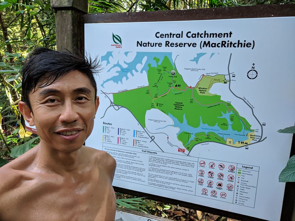
The original route directs me to run along Lornie road, up Marymount road before reaching Bishan Park (see dotted path). But I decided it would be more fun to make a detour inside MacRitchie reservoir for some off road action, run towards Venus Drive, and head towards Bishan park along Upper Thomson road. See below (Detour in Red)

Turn left to enter the MacRitchie Trail at the exit for the 4.8KM cross country running route. You should see this sign. Study the map carefully if you are not familiar with the area, you will want to find the route that heads towards the ranger station.
Run along the boundary of the golf course and reservoir, you will see a wooden walk way. Continue on along the rocky track (Sime Track), pass Jelutong Tower, Petaling Hut, until you get to the Ranger Station. Take a break here if needed.

Continue on along Terentang trail until you see the famous stone marker. Make sure to follow the sign to Venus Drive.

You will run along Dorongo Trail, Squirrel Trial, Venus Loop before reaching the drop off point. There is another toilet here for you to take a break. Head towards the main road (upper Thomson Road), cross the road and turn left towards Bishan Park. See map below (detour in red). Once you see Bishan Park, turn right and run along the Park pavement. You should see another toilet near the pond garden (point E on map) for you to take a quick drink.


Phew that was a long one. Congratulations, you have reached (about) the mid-way point.
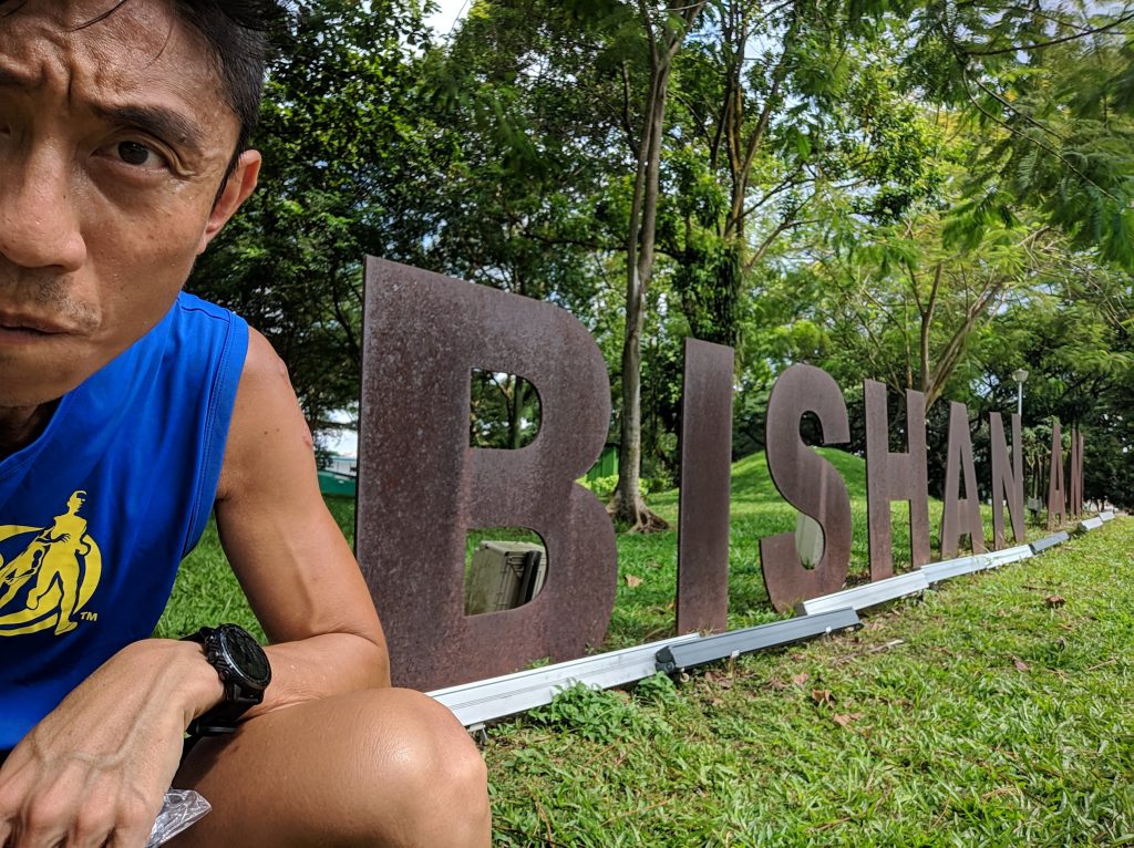
CP5 Bishan Park
After a short break, I ran towards Ang Mo Kio Avenue 6 junction. Notice in the pic below that I had my shirt on again as the sun is blazing down and the temperature is getting hotter by the minute. This was the only thing I could do to not become chao da.
Made a left and continue onward along AMK Ave 6 until I reached the Shell Petrol Station. Went in and bought a 100 Plus Zero for my midpoint break. As it has no sugar, I am technically still in a fasted state.

After downing 500ml, I continue my run towards AMK Town Garden West

Another few hundred meters later, I turned right at the AMK Ave 5 junction and continue on along the AMK park connector. It must be close noon now as the sun was blazing at full strength. I continued my run past Anderson JC, NanYang Poly and AMK ITE. Ran underneath the CTE flyover before I reached the next CP, Luxus Hill Park. This was only a mere 3KMs but it felt like 10.

CP6 – Luxus Hill Park

I cross the bridge across Sungei Punggol, made a left turn and cross the traffic light after a petrol station. You can have another break here but I did not stop for one.
I descended a flight of stairs towards Gerald drive and continue along the “longkang” towards my next CP, Segkang Floating Wetland.
This was a really long stretch (or at least it felt like it) and my feet got heavier with every single step. It was well past noon and I thought my regular lunchtime run had prepared me for the blazing hot sun, but it felt different when you had just run 30KM.

CP7 – Sengkang Floating Wetland

The CP was just beside the Sengkang sport complex stadium.

I was getting really thirsty, so I head towards the toilet near the stadium but they were all locked. I pushed on until I reached Anchorvale CC, and I saw this (Legend Beer Bar). It was like an oasis in the desert. I will definitely be back to try out the beer.

I tried to look for the toilet around here, and I finally found it at level 2. Tap water had never tasted so good. Time to head towards CP8 – Punggol Waterway Park.
I reduced to a run-walk speed at this point. After crossing the Punggol Waterway footbridge, I picked up my pace towards SAFRA Punggol.

I was looking high and low for another toilet along the way as the sign indicated there was one nearby. It turned out you have to cross the Adventure bridge to get to it.


CP8 – Punggol Waterway Park

SAFRA Punggol looming across the “longkang”

Another 3KM to go before I reached the final CP – Coney Island

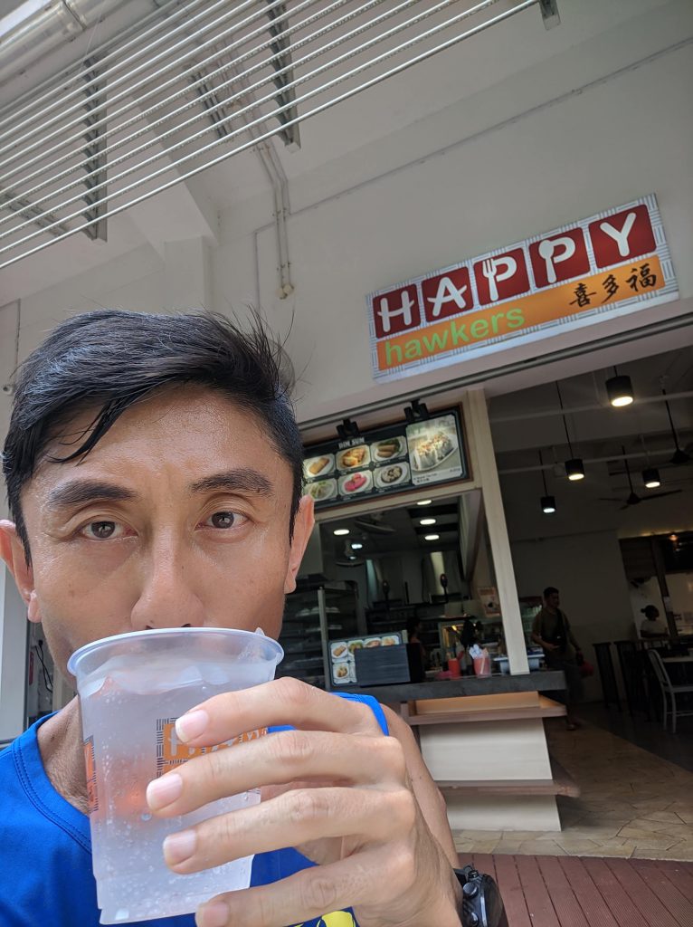
Dead tired, I longed for a drink. Luckily I saw a coffee shop. I indulged in my drink of Oldenlandia, better known as 白花蛇草水. It is, you guess it, zero calorie and I do not have any energy replenishment throughout the entire run. Yeah, maximum FAT BURN!!
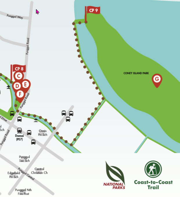
CP9 – Coney Island
I continued on along the waterway, made a left turn for the final sprint.

I made it!!!

Time to head home.

Conclusion
Another run completed, I never thought I could complete it and I certainly have my doubts midway. But I am glad I persisted and I can look back at my accomplishment a few years down the road.
I highly recommend this route for a seasoned runner, but if you planned to walk this trail, it can take you close to 8 hrs, so it would be better if you split it across 2 separate days.
Hope this long post is useful to you. Happy jogging/hiking!
Final Stats
- Total Distance – 40.12km (might be slightly off)
- Total moving time – 4:05:01
- Total Elapsed time – 5:47:19 (those time taking photos and looking for toilet really add up)
- Total Calorie burnt – 3,050 (Zero calorie intake throughout the entire run)
Check out my run at Strava
Cheers!